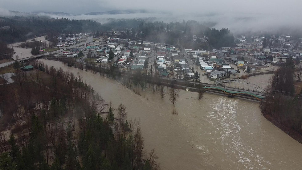
BC Flooding Strands hundreds, Forces Evacuation of Merritt
- ExNews.net

- Nov 15, 2021
- 3 min read
Updated: Oct 23, 2024
November 15, 2021,
Merritt BC has been evacuated as of 10 am this morning. Sewer and water systems are overwhelmed by the volume of water. Residents are heading to Kamloops or Kelowna Emergency Shelters.

Hundred of motorists trapped between 2 landslides on highway 7 near Agassiz had to be airlifted by a Canadian Forces helicopter this afternoon.
The fear now is were any vehicles or occupants swept away by the torrent of mud and debris.
Princeton BC has also been hit hard by floods. Hundreds of residents were forced from their homes after the Similkameen river breached a dike early Monday morning. The water rose so quickly people had little time to escape to higher ground. Some crawling out windows.
Record breaking flooding has crippled many BC roads through Southern British Columbia's coastal and region.
The Coquihalla remains closed in both directions due to a mudslide, as does Highway #1 through the Fraser Canyon. The hope Princeton is also closed.

All three major routes from the coast to the interior closed has prevented hundreds of trucks carrying food and other essential good across the province. Perishable goods like fruits and vegetables are already becoming scarce on grocery shelves.

So far crews have not been able to safely assess the extent of road damage on the major highways. It will take days if not weeks to return the routes to normal.

For example, a large section of the Coquihalla has been washed away.
The weather event is being called "historical" by experts. Some areas have seen over 200mm of rainfall the last few days.
Infrastructure designed to divert the water is unable to cope.
Of particular concern is the possible failure of sewer systems in some outlying areas.
The flooding extends from Vancouver, the Fraser Valley as far as Merritt and Princeton.
The high water is flooding city streets and forcing the closure of major highways.
Rivers are also running extremely high.
The rain started Sunday, increasing in intensity causing mudslides on the Coquihalla and Highway 7 near Agassiz. Dozens of motorists, some spending the night in their vehicles.
Environment Canada has issued extreme weather alerts for much of southern BC
Road Closures as of Monday Morning, Next Update From Drive BC 12 Noon:
- Highway 7, in both directions. Flooding between Highlands Blvd and Bodnar Rd (Kent). Road closed. Assessment in progress. Estimated time of opening not available. Next update time Mon Nov 15 at 7:00 AM PST. Last updated Sun Nov 14 at 11:51 PM PST. (DBC-35098)
- Highway 7, in both directions. Flooding between 240 St and 272 St for 6.3 km (Maple Ridge). Road closed. Estimated time of opening not available. Assessment in progress. Detour in effect. Next update time Mon Nov 15 at 8:00 AM PST. Last updated Mon Nov 15 at 6:11 AM PST. (DBC-35088)
- Highway 1, in both directions. Travel advisory in effect between Annis Rd and Exit 170 for 35.0 km (1 km east of Chilliwack to Hope). Heavy rain. Mudslide. Assessment in progress. Mudslide events and flooding east of Chilliwack, avoid unnecessary travel, expect closures and major delays. Next update time Mon Nov 15 at 7:00 AM PST. Last updated Mon Nov 15 at 12:00 AM PST. (DBC-35073)
- Highway 3, in both directions. Mudslide at Sunshine Valley (17 km east of Hope). Assessment in progress. Estimated time of opening not available. Next update time Mon Nov 15 at 9:00 AM PST. Last updated Sun Nov 14 at 11:05 PM PST. (DBC-35108)
- Highway 1, in both directions. Travel advisory in effect between Ross Rd and Jackass Summit for 81.6 km (Hope to 4 km south of Jackass Mountain Summit). Due to debris in water. Road open to traffic. Next update time Mon Nov 15 at 9:00 AM PST. Last updated Sun Nov 14 at 8:19 PM PST. (DBC-35096)
- Highway 1, in both directions. Travel advisory in effect between Junction Hwy 12 and Junction Hwy 8 for 35.5 km (Lytton to Spences Bridge). Heavy rain. Heavy rain forecast Sun Nov 14 to Tue Nov 16. Closure may result due to the risk of sudden debris flows in fire affected areas. Motorists are advised to exercise caution when travelling and consider alternate routes. Next update time Tue Nov 16 at 9:00 AM PST. Last updated Sun Nov 14 at 8:10 PM PST. (DBC-35067)
- Highway 5, in both directions. Mudslide between Exit 202 and Exit 217: Zopkios Brake Check (8 km south of Great Bear Snowshed). Road closed. Assessment in progress. Estimated time of opening not available. Detour not available. Next update time Mon Nov 15 at 12:00 PM PST. Last updated Mon Nov 15 at 3:27 AM PST. (DBC-35063)
Links to our favorite flood videos made by citizen journalists posted on YouTube


Comments